publications
Peer-reviewed publications in reversed chronological order.
2026
- BAMS
 IdentificatioN of Sources of Precipitation through an International Research Effort (INSPIRE): Three Extreme Precipitation Case StudiesImme Benedict, Jessica Keune, Chris Weijenborg, and 30 more authorsBulletin of the American Meteorological Society, Aug 2026
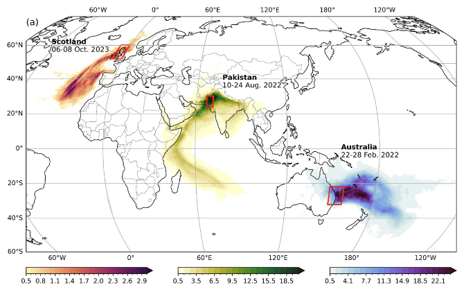
Extreme precipitation events can have severe impacts on society and the environment. Understanding what causes these events is a vital step toward better prediction and improved disaster preparedness. One research direction is to answer the question: Where did the moisture that rained here come from? The moisture sources for precipitation (i.e., where the moisture originally evaporated) cannot be measured directly and, therefore, a variety of different moisture-tracking methods have been developed and evolved over time. To better understand the uncertainty of these methods, we unite the community to advance common understanding and guidelines. As the first step, in this study, we quantify moisture sources of three extreme precipitation events using methods obtained from 14 different research groups. These three events cover different meteorological conditions: monsoon precipitation in Pakistan, convective precipitation in Australia, and atmospheric river-associated precipitation over Scotland. We find that for the three cases, the different moisture-tracking methods qualitatively agree in moisture source patterns, but there are regional and quantitative differences. For example, for the Pakistan case, the recycling ratio shows a multimethod spread of 2%–20%. We also find similar behavior across methods for the three different events, where methods consistently show either more recycling or more sources further away from the precipitation region. This coordinated model intercomparison facilitates the explanation and quantification of uncertainty, acting as a point of reference and inspiration for future work and literature on moisture tracking.
- ESSD
 A Four-Decade Global Lagrangian Air-Parcel Trajectory Dataset for Atmospheric Moisture and Heat AnalysisVictoria M. H. Deman, Damián Insua-Costa, Jessica Keune, and 2 more authorsEarth System Science Data, Jul 2026
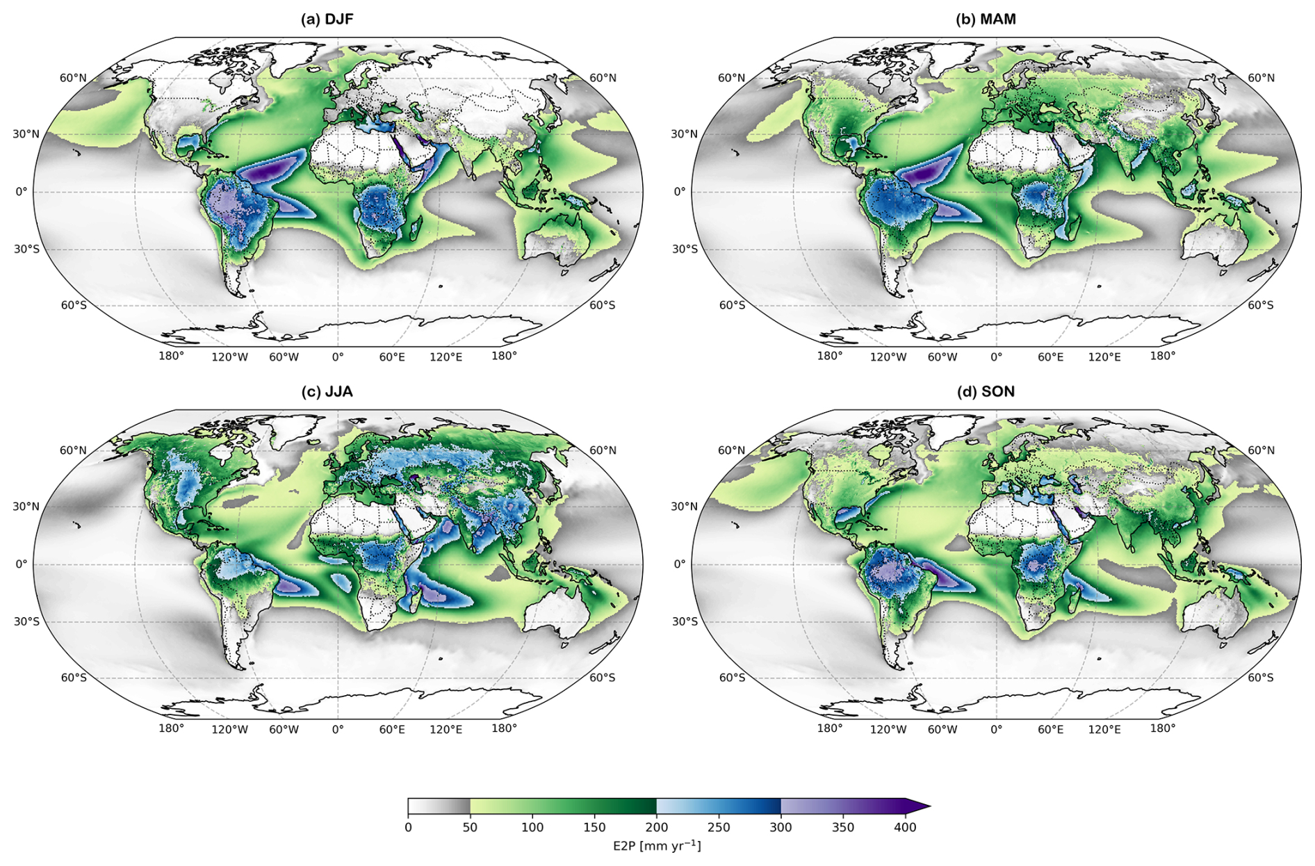
Studying the pathways of atmospheric moisture and heat is crucial for understanding global water and energy cycles, and their response to climate change. Here, we present a new global dataset of atmospheric parcel trajectories generated with the FLEXible PARTicle dispersion model (FLEXPART v11) and forced by ERA5 reanalysis. The dataset spans 1979–2024 and provides a consistent and physically grounded record for studying Lagrangian moisture and heat transport. The dataset includes 20 million global, domain-filling air-parcel trajectories together with their (thermo)dynamic properties, enabling detailed investigation of long-range atmospheric transport processes. By providing the complete trajectory archive openly, the dataset enables quantitative analyses of moisture and heat pathways without the need to perform computationally expensive Lagrangian simulations. While the trajectory dataset itself can be used with any moisture and heat tracking attribution methodology, here it is explored using the new version of the Heat And MoiSture Tracking framEwoRk (HAMSTER v2). The dataset’s usability is demonstrated by (i) global analyses of moisture source–sink patterns and recycling over multiple decades, (ii) global attribution of diabatic temperature increments to upwind surface sensible heat fluxes for a representative year (2021), and (iii) two local-scale case studies which showcase how the dataset and associated tools can be applied to hydrological and temperature extremes across a range of spatial and temporal scales. Overall, this resource lowers computational barriers and supports reproducible research across the atmospheric science community. The dataset is available at https://doi.org/10.5281/zenodo.17952362 (Deman et al., 2025).
- ERL
 Irrigated Agriculture Supports Rainfed Crops in India through Atmospheric Moisture RecyclingAkash Koppa, Francesca Bassani, Jessica Keune, and 6 more authorsEnvironmental Research Letters, May 2026
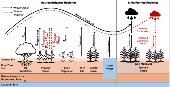
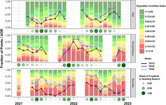
Abstract Rainfed crops account for approximately 40% of India’s food production and support 60% of its livestock. Although linked to oceanic monsoon rainfall, their productivity also depends on terrestrially-sourced rainfall, particularly in the non-monsoon season. The degree to which rainfed crops rely on moisture sourced from evaporation in upwind irrigated areas remains largely unknown. Using a combination of models and observations, we show that evaporation from upwind irrigated crops contributes 7% (mean) \textpm 5% (spread) of the rainfall over rainfed areas annually, rising to 15 \textpm 10% during the pre-monsoon months (averaged over the years 2000–2020). In the absence of this input, water stress experienced by rainfed crops can increase by 5%–10% during the crucial mid to late crop growth phases, potentially affecting yields. Our results reveal an unrecognized atmospheric link between irrigated and rainfed agriculture that is overlooked in current agricultural policies. Planning and managing these systems holistically can help strengthen regional food and water security under future climates.
2025
- SD
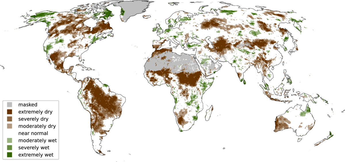 ERA5–Drought: Global Drought Indices Based on ECMWF ReanalysisJessica Keune, Francesca Di Giuseppe, Christopher Barnard, and 2 more authorsScientific Data, Apr 2025
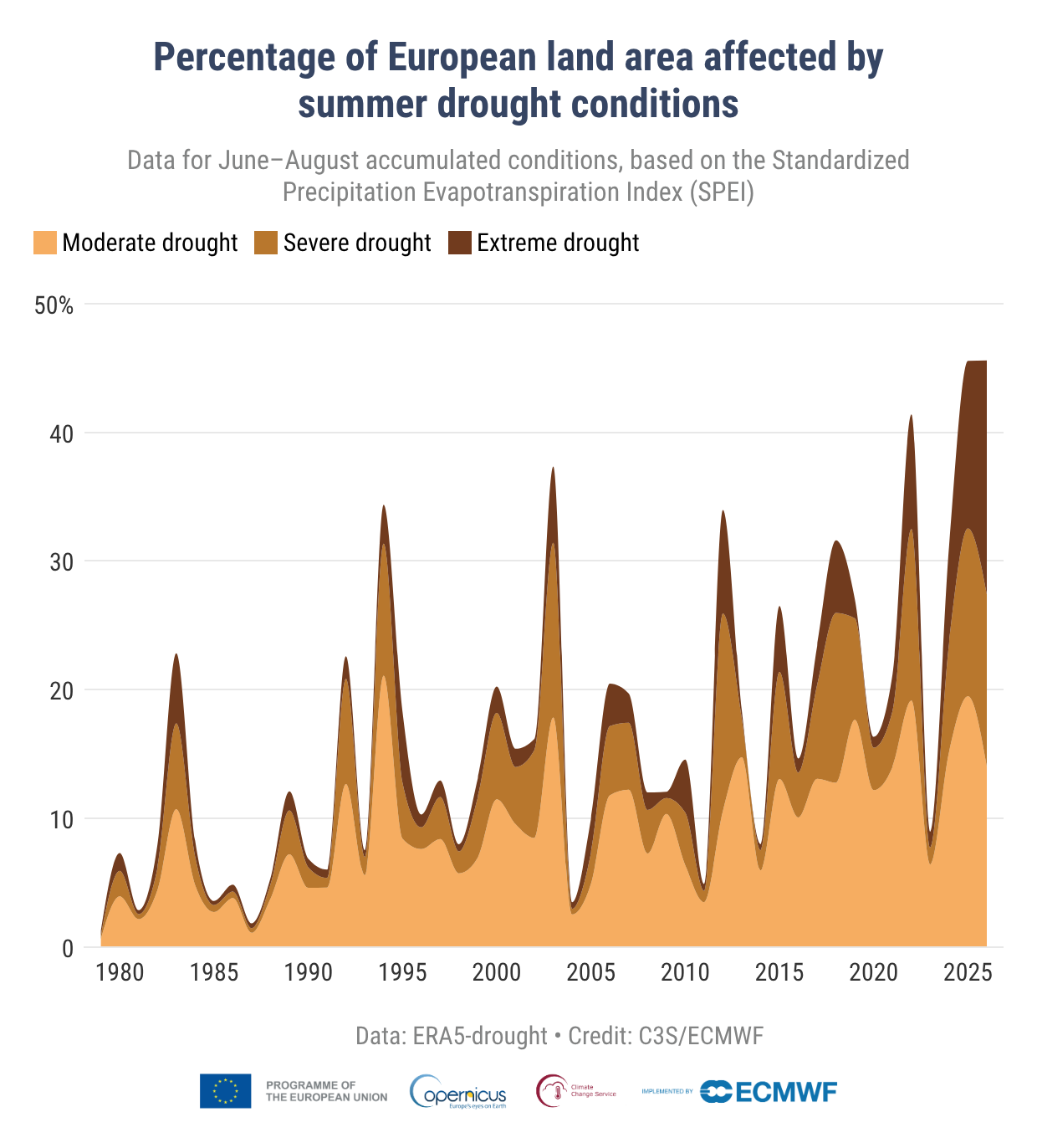
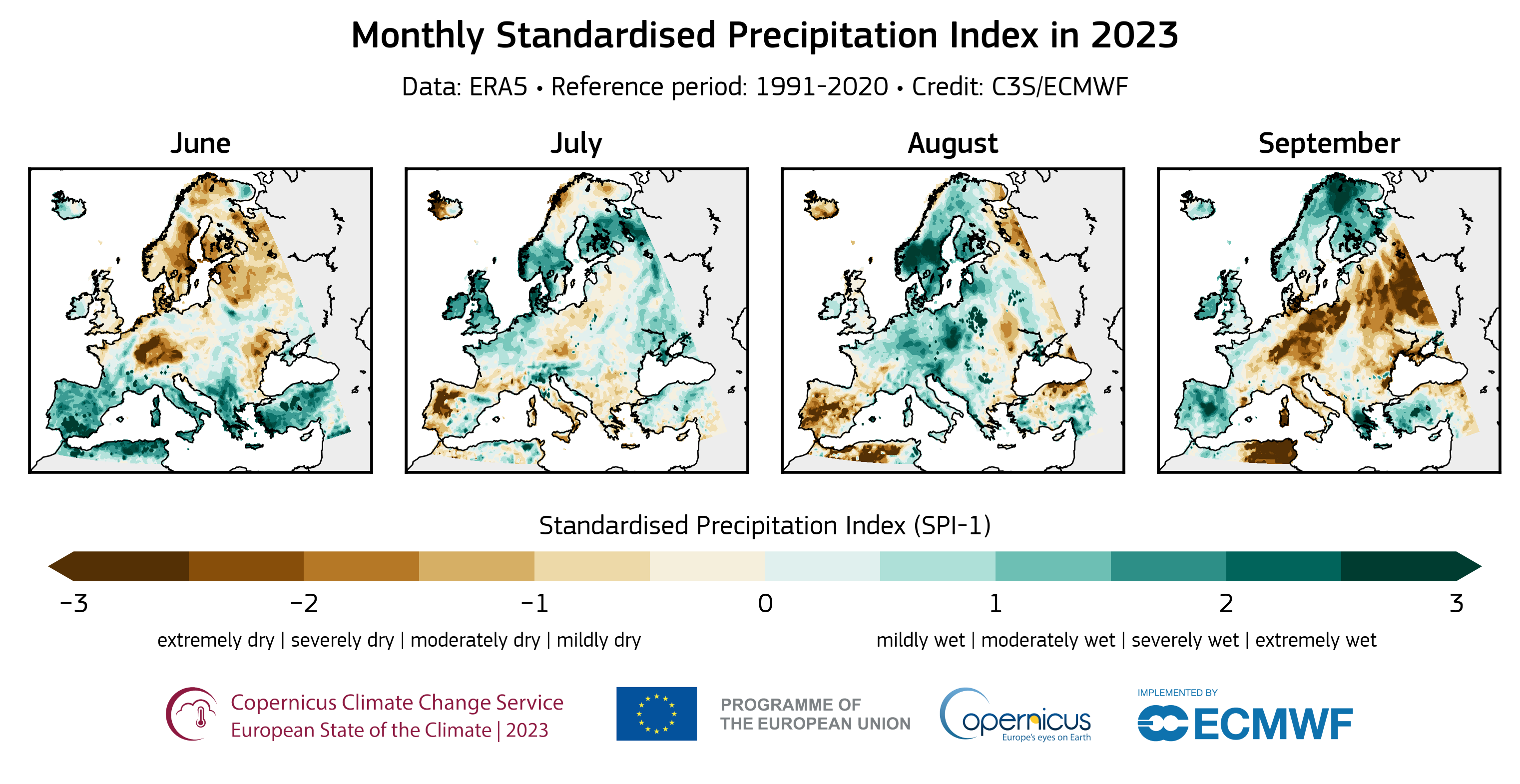
Droughts are increasingly intensified by human-induced climate change and pose a growing threat to society. Thus, enhancing our capabilities to monitor drought occurrence and intensity is crucial. This paper introduces a new dataset of drought indices derived from the 5th generation ECMWF reanalysis system (ERA5), which offers long-term monitoring of the global climate in both deterministic and probabilistic forms. This global dataset is freely accessible through an ECMWF-hosted data store, and it entails two prominent drought indices: the Standardized Precipitation Index (SPI) and the Standardized Precipitation Evapotranspiration Index (SPEI). Both indices are calculated over a range of accumulation periods from 1 month to 4 years and are available for the full ERA5 climatology from 1940 to today. It also contains validation data that indicates the quality of these drought indices. The ERA5–Drought dataset serves as a valuable tool for environmental agencies and supports sectors such as water management and agriculture, thus contributing to efforts that monitor water and food security.
- npj-CAS
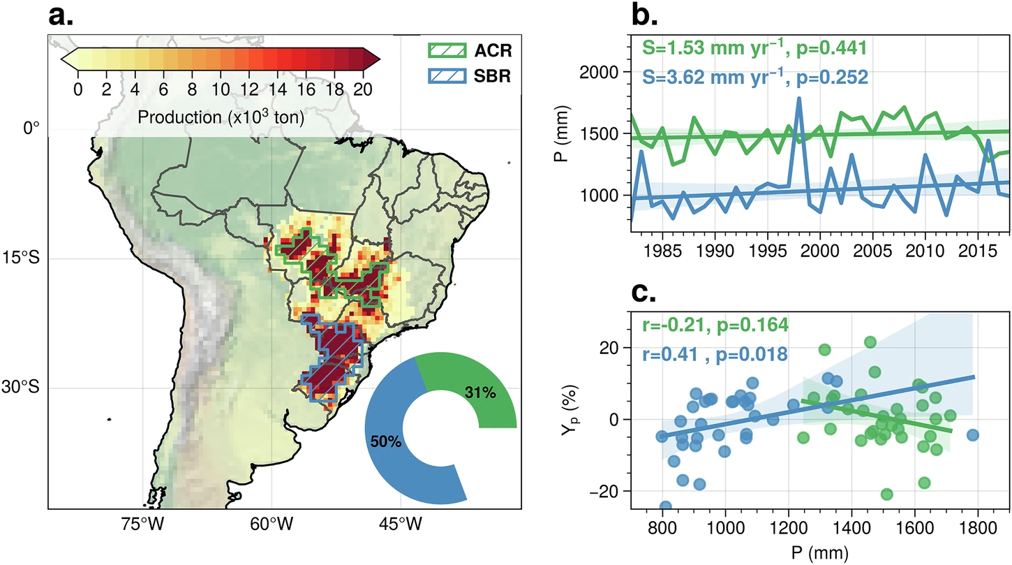 Observational Evidence of Compensatory Influences of Deforestation on Downwind Precipitation in Brazilian BreadbasketsHao Li, Damián Insua-Costa, Akash Koppa, and 7 more authorsnpj Climate and Atmospheric Science, Jul 2025
Stable and predictable wet-season rainfall is crucial for soybean production in Brazil. However, climate and land-use changes, particularly Amazon deforestation, have increased rainfall variability in the region in recent decades. Here, we investigate long-term growing-season rainfall changes over two major soybean breadbaskets in Brazil from the perspective of atmospheric moisture transport. Utilising a novel moisture tracking framework based on a Lagrangian model guided by observations, we identify moisture source regions where evaporation contributed to rainfall over these breadbaskets. Furthermore, we quantify the relative contributions of source evaporation versus atmospheric (thermo)dynamics changes to downwind rainfall variability. Our results indicate that deforestation-induced evaporation declines have negatively impacted downwind rainfall in the breadbasket regions. However, strengthened circulation, evidenced by increased water vapour transport and low-level wind speeds consistent with decreased tree cover, has enhanced moisture transport from upwind regions (including Amazonia and the Atlantic Ocean) to the Brazilian soybean breadbaskets. This highlights the compensatory effects of deforestation on rainfall through decreased evaporation and altered atmospheric (thermo)dynamics, and how these effects may influence downwind soybean productivity in South America. Further understanding these interactions is critical for developing land management strategies to mitigate the agricultural impacts of climate change in the region.
- GCB
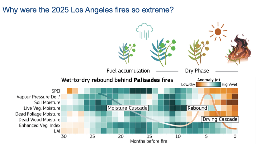 Hydroclimatic Rebound Drives Extreme Fire in California’s Non-Forested EcosystemsJoe McNorton, Alberto Moreno, Marco Turco, and 2 more authorsGlobal Change Biology, 2025
The catastrophic Los Angeles Fires of January 2025 underscore the urgent need to understand the complex interplay between hydroclimatic variability and wildfire behavior. This study investigates how sequential wet and dry periods, hydroclimatic rebound events, create compounding environmental conditions that culminate in extreme fire events. Our results show that a cascade of moisture anomalies, from the atmosphere to vegetation health, precedes these fires by around 6–27 months. This is followed by a drying cascade 6 months before ignition that results in anomalously high and dry fuel loads conducive to fires. These patterns are confirmed when analyzing recent (2012–2025) extreme fire events in Mediterranean and Desert Californian biomes. We find hydroclimatic rebound as a key mechanism driving extreme wildfire risk, where moisture accumulation fuels vegetation growth that later dries into highly flammable fuel. In contrast, extreme fires in the fuel-rich Forested Mountain regions are less influenced by the moistening cascade and more impacted by prolonged drought conditions, which typically persist up to 11 months prior to fire occurrence. These insights improve fuel-informed operational fire forecasts for the January 2025 Los Angeles fires, particularly when year-specific fuel conditions are included. This underscores the value of incorporating long-memory variables to better anticipate extreme events in fuel-limited regions.
- NCom
 Compounding Future Escalation of Emissions- and Irrigation-Induced Increases in Humid-Heat StressYi Yao, Yusuke Satoh, Nicole van Maanen, and 14 more authorsNature Communications, Oct 2025
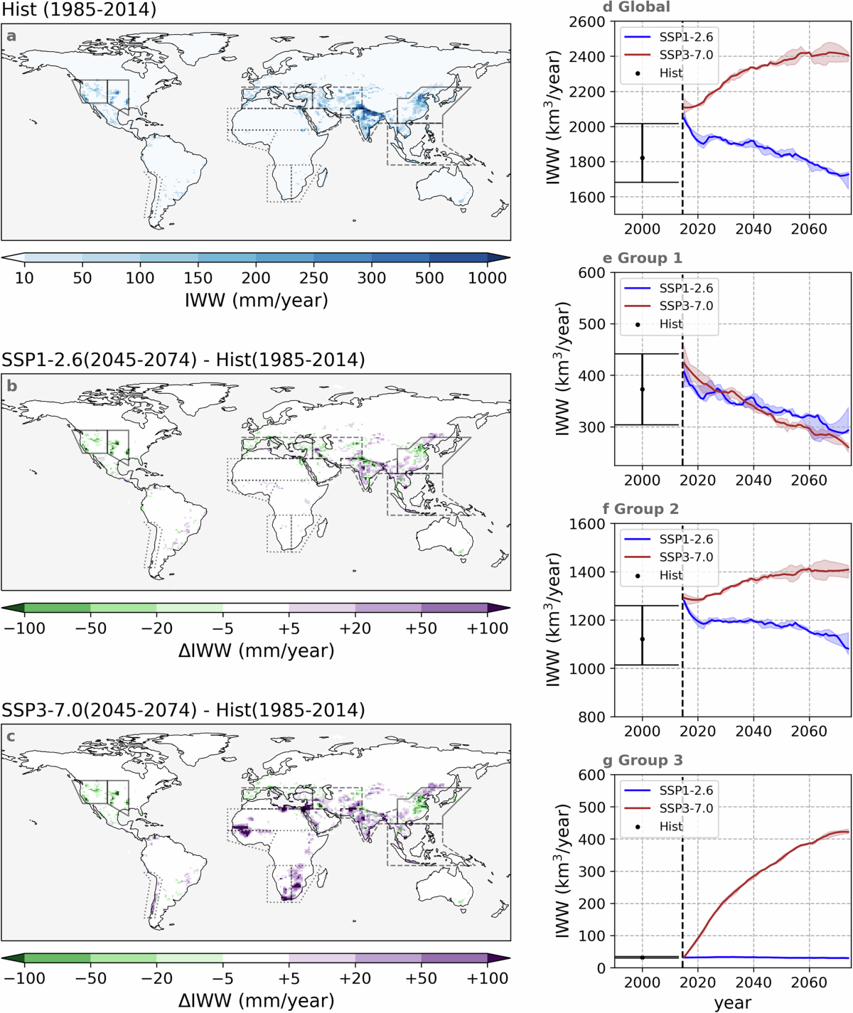
Irrigation has been investigated as an important historical climate forcing, but there is no study exploring its future climatic impacts considering possible changes in both extent and efficiency. Here, we address these issues via developing irrigation efficiency scenarios in line with the Shared Socioeconomic Pathways (SSPs), implementing these in the Community Earth System Model, and applying them to generate projections over the period 2015–2074. We project that annual irrigation water withdrawal decreases under SSP1-2.6 (from ~2100 to ~1700 km3 yr-1) but increases under SSP3-7.0 (to ~2400 km3 yr-1), with some new irrigation hot spots emerging, especially in Africa. Irrigation is projected to reduce the occurrence of dry-heat stress under both scenarios, but cannot reverse the warming trend due to greenhouse gas emission (e.g., increasing from ~90 to around 600 and 1200 hours yr-1 in intensely irrigated areas, under two scenarios). Moreover, moist-heat extreme event frequency increases more substantially (by ≥1600 hours yr-1 under SSP3-7.0 in tropical regions), and irrigation further amplifies the hours of exposure (for example, by ≥100 hours yr-1 in South Asia), thereby raising the risk of moist-heat-related illnesses and mortality for exposed communities. Our results underscore the importance of reducing greenhouse gas emissions, limiting irrigation expansion and improving irrigation efficiency to preserve water resources and decelerate escalating exposure to dry- and moist-heat stress.
2024
- ESD
 Effects of Idealized Land Cover and Land Management Changes on the Atmospheric Water CycleSteven J. De Hertog, Carmen E. Lopez-Fabara, Ruud van der Ent, and 13 more authorsEarth System Dynamics, Mar 2024
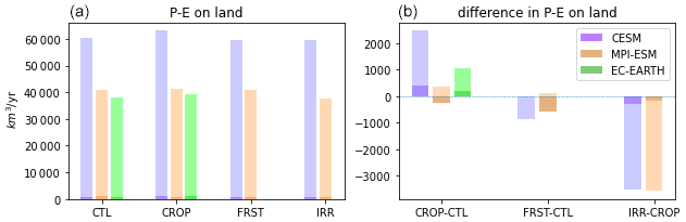
Land cover and land management changes (LCLMCs) play an important role in achieving low-end warming scenarios through land-based mitigation. However, their effects on moisture fluxes and recycling remain uncertain, although they have important implications for the future viability of such strategies. Here, we analyse the impact of idealized LCLMC scenarios on atmospheric moisture transport in three different Earth system model (ESMs): the Community Earth System Model (CESM), the Max Planck Institute Earth System Model (MPI-ESM), and the European Consortium Earth System Model (EC-EARTH). The LCLMC scenarios comprise of a full cropland world, a fully afforested world, and a cropland world with unlimited irrigation expansion. The effects of these LCLMC in the different ESMs are analysed for precipitation, evaporation, and vertically integrated moisture flux convergence to understand the LCLMC-induced changes in the atmospheric moisture cycle. Then, a moisture tracking algorithm is applied to assess the effects of LCLMC on moisture recycling at the local (grid cell level) and the global scale (continental moisture recycling). By applying a moisture tracking algorithm on fully coupled ESM simulations we are able to quantify the complete effects of LCLMC on moisture recycling (including circulation changes), which are generally not considered in moisture recycling studies. Our results indicate that cropland expansion is generally causing a drying and reduced local moisture recycling, while afforestation and irrigation expansion generally cause wetting and increased local moisture recycling. However, the strength of this effect varies across ESMs and shows a large dependency on the dominant driver. Some ESMs show a dominance of large-scale atmospheric circulation changes while other ESMs show a dominance of local to regional changes in the atmospheric water cycle only within the vicinity of the LCLMC. Overall, these results corroborate that LCLMC can induce substantial effects on the atmospheric water cycle and moisture recycling, both through local effects and changes in atmospheric circulation. However, more research is needed to constrain the uncertainty of these effects within ESMs to better inform future land-based mitigation strategies.
- Science
 Dryland Self-Expansion Enabled by Land–Atmosphere FeedbacksAkash Koppa, Jessica Keune, Dominik L. Schumacher, and 4 more authorsScience, Aug 2024
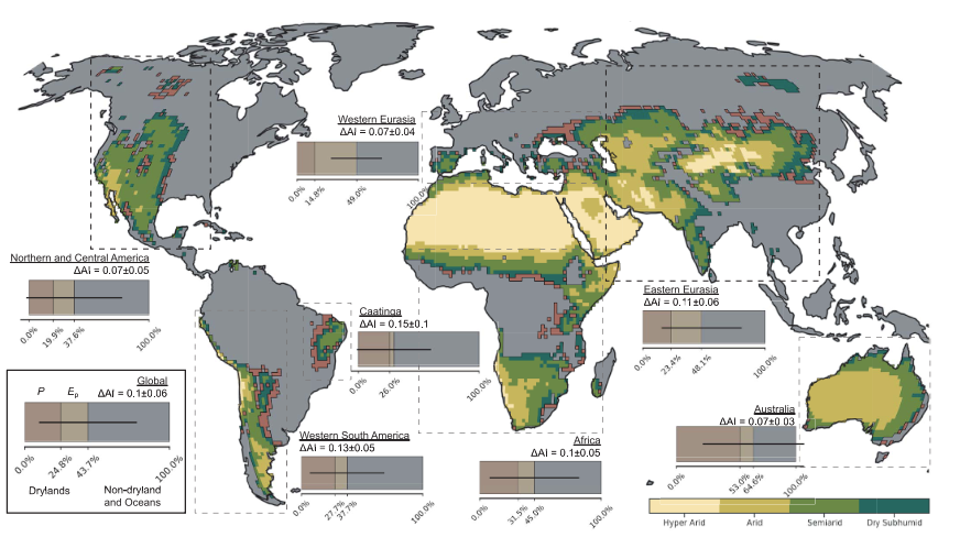
Dryland expansion causes widespread water scarcity and biodiversity loss. Although the drying influence of global warming is well established, the role of existing drylands in their own expansion is relatively unknown. In this work, by tracking the air flowing over drylands, we show that the warming and drying of that air contributes to dryland expansion in the downwind direction. As they dry, drylands contribute less moisture and more heat to downwind humid regions, reducing precipitation and increasing atmospheric water demand, which ultimately causes their aridification. In ~40% of the land area that recently transitioned from a humid region into a dryland, self-expansion accounted for >50% of the observed aridification. Our results corroborate the urgent need for climate change mitigation measures in drylands to decelerate their own expansion.
- EF
 Heat and Moisture Anomalies During Crop Failure Events in the Southeastern Australian Wheat BeltHao Li, Jessica Keune, Qiqi Gou, and 2 more authorsEarth’s Future, 2024
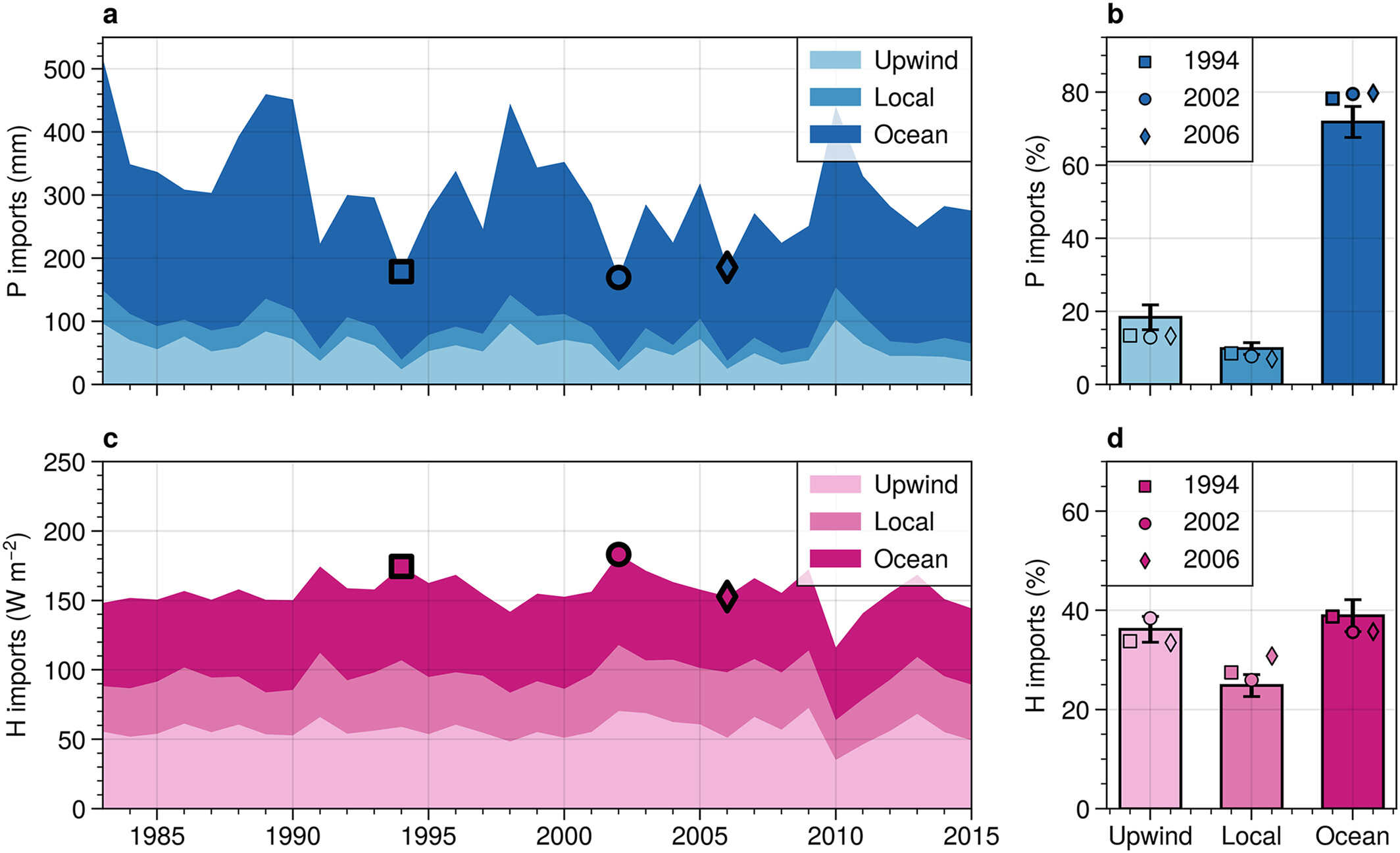
Prolonged droughts and heatwaves are common causes of agricultural failure in Australia, yet the origins of these climate anomalies remain understudied. Here, we use a Lagrangian trajectory model driven by atmospheric reanalysis and constrained by satellite data to unravel the sources of precipitation and heat over the Southeastern Australia wheat belt. Furthermore, we assess the impact of local and upwind drought conditions on the moisture and heat imports to the region. Results indicate that the most extreme crop failure events over the wheat belt (i.e., 1994, 2002, and 2006) were associated with persistent high-pressure systems. The ocean provided on average 72% of the moisture for precipitation and 39% of the heat arriving over the wheat belt, with the moisture sources substantially decreasing during crop failure events. Upwind drought further intensified rainfall deficits and heat stress during these events due to lower moisture and higher heat imports to the region. This was particularly clear during the initial phase of the Millennium Drought in 2002. Then, yield deficits exceeded 50%, and ∼4% of the precipitation originated from drought-affected regions upwind, compared to the 9% that was expected climatologically from those regions. Simultaneously, the heat import from these regions upwind increased by ∼10 W m-2, from the climatological 23%–25%, during this event. While these results indicate a limited potential for upwind land management to mitigate downwind agricultural loss in the Southeastern Australia wheat belt, other agricultural regions with a higher climatic dependency on remote land may benefit from such strategies.
- GRL
 Critical Importance of Tree and Non-Tree Vegetation for African PrecipitationS. A. Te Wierik, J. Keune, D. G. Miralles, and 4 more authorsGeophysical Research Letters, 2024
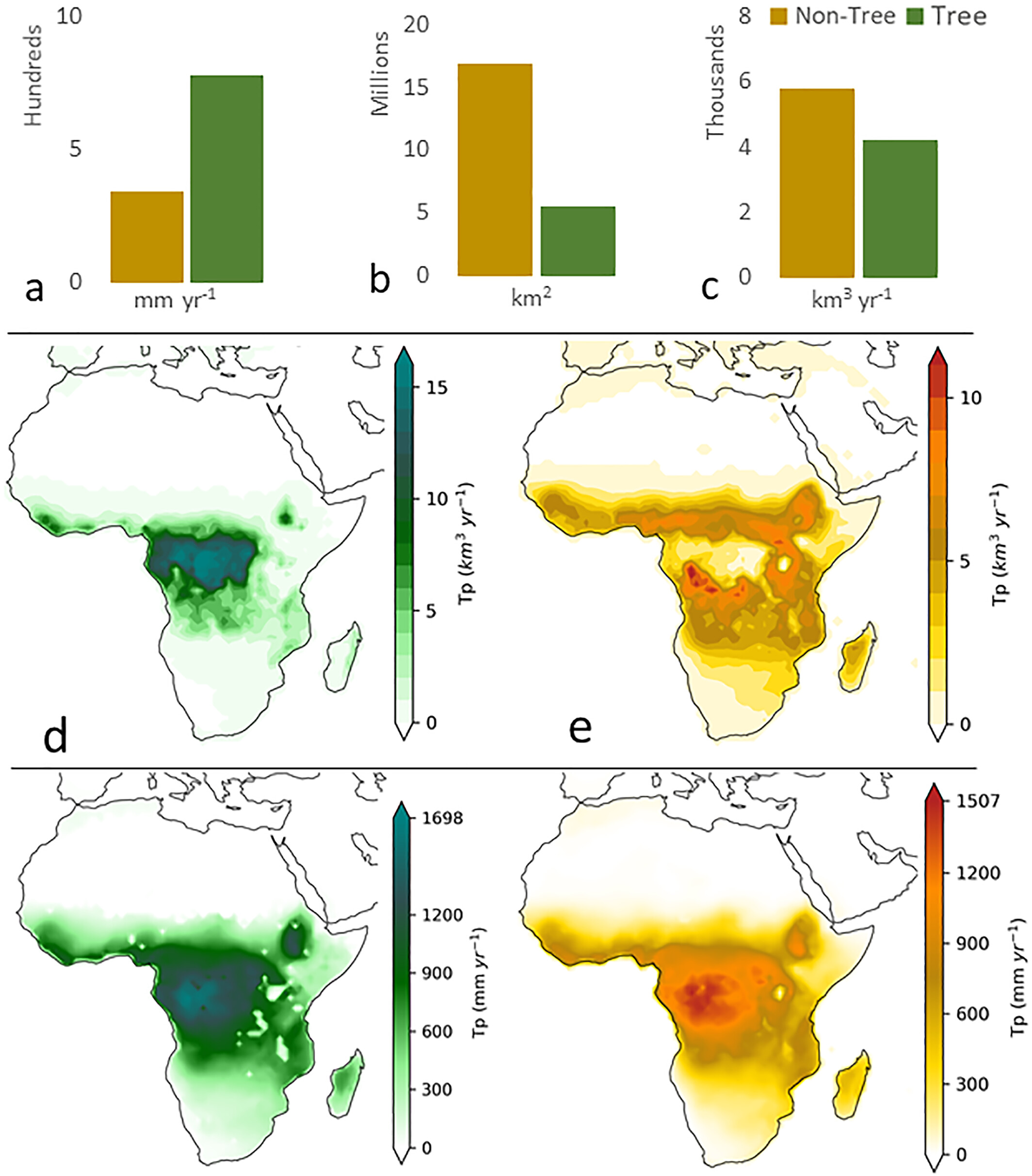
Vegetation is a major contributor of terrestrial evaporation and influences subsequent precipitation over land. Studies suggest that forests are crucial for moisture recycling, although the specific contribution of different vegetation to precipitation remains unclear. Using a moisture recycling approach, we investigate the contribution of transpiration from trees and non-tree vegetation to precipitation over Africa. We use precipitation source regions from simulated atmospheric moisture trajectories, constrained by observation-based evaporation and precipitation products, and fractional vegetation cover data. Our findings show that trees provide a higher flux to precipitation (∼777 mm year-1) than non-tree vegetation (∼342 mm year-1). However, considering the smaller spatial extent of trees compared to non-tree vegetation, precipitation in most watersheds effectively depends more on the latter. Overall, non-tree vegetation appears equally important as trees in terms of volumetric contributions to precipitation, and deserves attention in further research, considering ongoing land use changes that affect the continental water cycle.
2023
- JGR-A
 A Lagrangian Analysis of the Sources of Rainfall Over the Horn of Africa DrylandsAkash Koppa, Jessica Keune, Dave A. MacLeod, and 8 more authorsJournal of Geophysical Research: Atmospheres, 2023
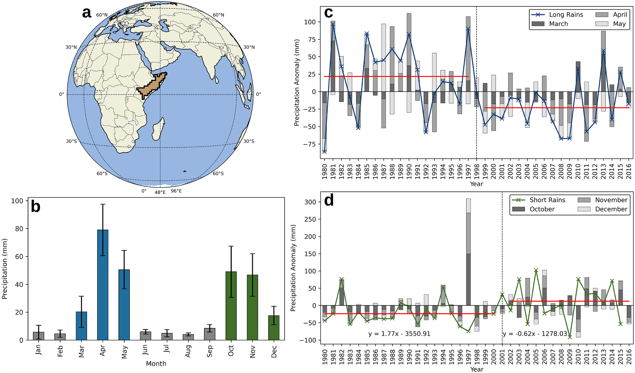
The Horn of Africa drylands (HAD) are among the most vulnerable regions to hydroclimatic extremes. The two rainfall seasons—long and short rains—exhibit high intraseasonal and interannual variability. Accurately simulating the long and short rains has proven to be a significant challenge for the current generation of weather and climate models, revealing key gaps in our understanding of the drivers of rainfall in the region. In contrast to existing climate modeling and observation-based studies, here we analyze the HAD rainfall from an observationally-constrained Lagrangian perspective. We quantify and map the region’s major oceanic and terrestrial sources of moisture. Specifically, our results show that the Arabian Sea (through its influence on the northeast monsoon circulation) and the southern Indian Ocean (via the Somali low-level jet) contribute ∼80% of the HAD rainfall. We see that moisture contributions from land sources are very low at the beginning of each season, but supply up to ∼20% from the second month onwards, that is, when the oceanic-origin rainfall has already increased water availability over land. Further, our findings suggest that the interannual variability in the long and short rains is driven by changes in circulation patterns and regional thermodynamic processes rather than changes in ocean evaporation. Our results can be used to better evaluate, and potentially improve, numerical weather prediction and climate models, and have important implications for (sub-)seasonal forecasts and long-term projections of the HAD rainfall.
- npj-CAS
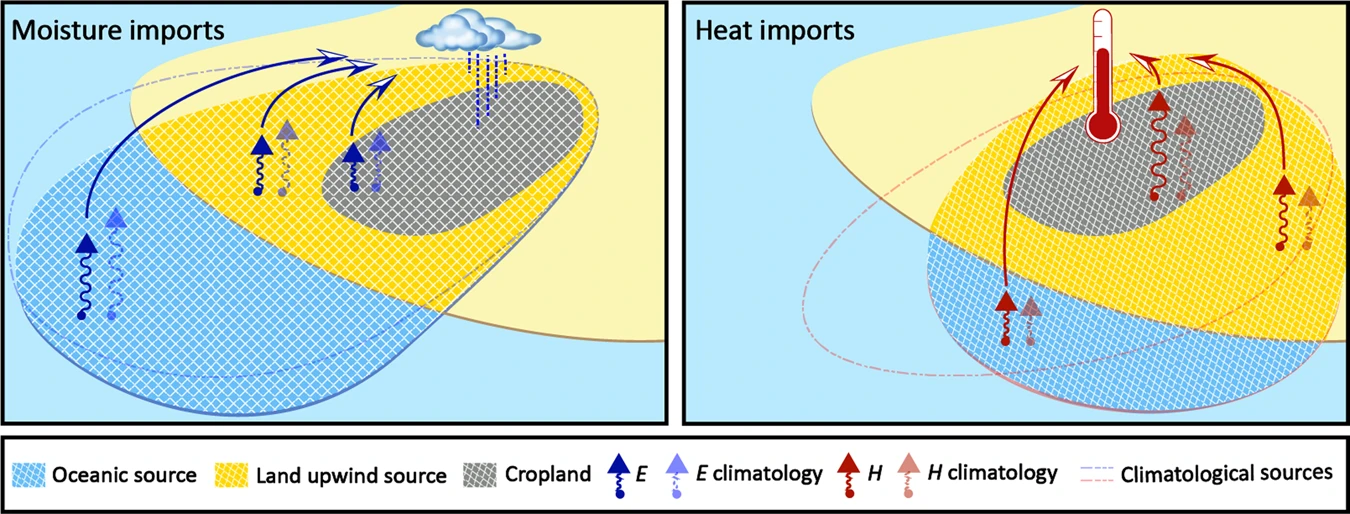 Land–Atmosphere Feedbacks Contribute to Crop Failure in Global Rainfed BreadbasketsHao Li, Jessica Keune, Femke Smessaert, and 3 more authorsnpj Climate and Atmospheric Science, May 2023
Global crop yields are highly dependent on climate variability, with the largest agricultural failures frequently occurring during extremely dry and hot years. Land–atmosphere feedbacks are thought to play a crucial role in agricultural productivity during such events: precipitation deficits cause soil desiccation, which reduces evaporation and enhances sensible heating from the land surface; the amplified local temperatures and moisture deficits can be detrimental to crop yield. While this impact of local land–atmosphere feedbacks on agricultural productivity has recently been reported, the dependency of crop yields on upwind regions remains understudied. Here, we determine the spatio-temporal origins of moisture and heat over the world’s largest 75 rainfed breadbaskets, and illustrate the crop yield dependency on upwind regions. Further, we disentangle the role of local and upwind land–atmosphere interactions on anomalous moisture and heat transport during low-yield years. Our results indicate that crop failure increases on average by around 40% when both upwind and local land–atmosphere feedbacks cause anomalously low moisture and high heat transport into the breadbaskets. The impact of upwind land–atmosphere feedbacks on productivity deficits is the largest in water-limited regions, which show an increased dependency on moisture supply from upwind land areas. Better understanding these upwind–downwind dependencies in agricultural regions can help develop adaptation strategies to prevent food shortage in a changing climate.
- NREE
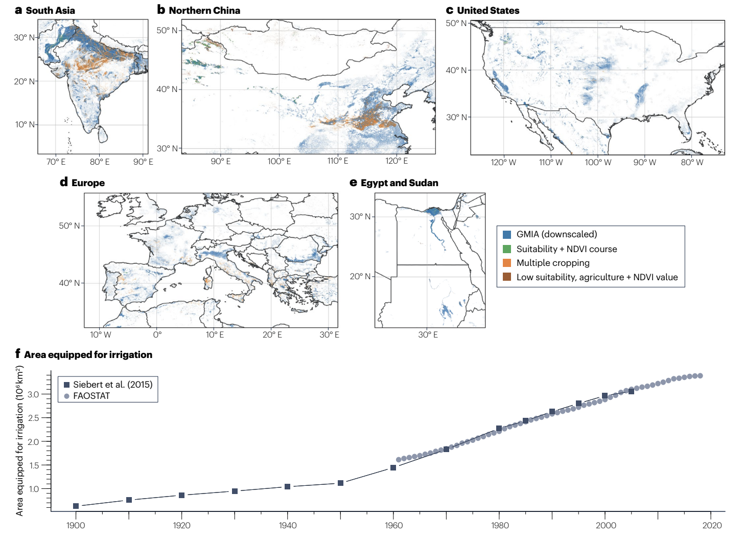 Irrigation in the Earth SystemSonali McDermid, Mallika Nocco, Patricia Lawston-Parker, and 35 more authorsNature Reviews Earth & Environment, Jul 2023
Irrigation accounts for a substantial proportion of global water usage and can have biophysical and biogeochemical impacts on Earth systems. This Review outlines key irrigation–Earth system interactions, and discusses the effect of future climate and socioeconomic changes on irrigation patterns and their interaction.
2022
- NGeo
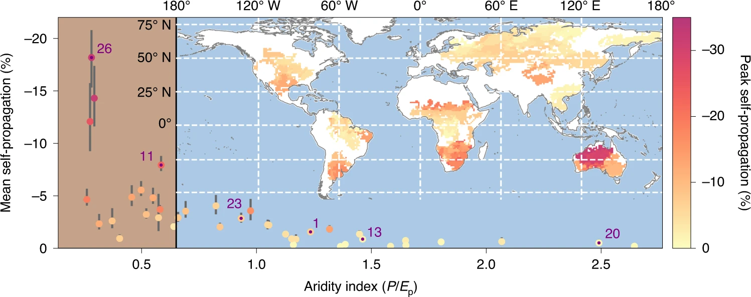 Drought self-propagation in drylands due to land–atmosphere feedbacksD. L. Schumacher, J. Keune, P. Dirmeyer, and 1 more authorNature Geoscience, 2022
Reduced evaporation due to dry soils can affect the land surface energy balance, with implications for local and downwind precipitation. When evaporation is constrained by soil moisture, the atmospheric supply of water is depleted, and this deficit may propagate in time and space. This mechanism could theoretically result in the self-propagation of droughts, but the extent to which this process occurs is unknown. Here we isolate the influence of soil moisture drought on downwind precipitation using Lagrangian moisture tracking constrained by observations from the 40 largest recent droughts worldwide. We show that dryland droughts are particularly prone to self-propagating because evaporation tends to respond strongly to enhanced soil water stress. In drylands, precipitation can decline by more than 15% due to upwind drought during a single event and up to 30% during individual months. In light of projected widespread reductions in water availability, this feedback may further exacerbate future droughts.
- GMD
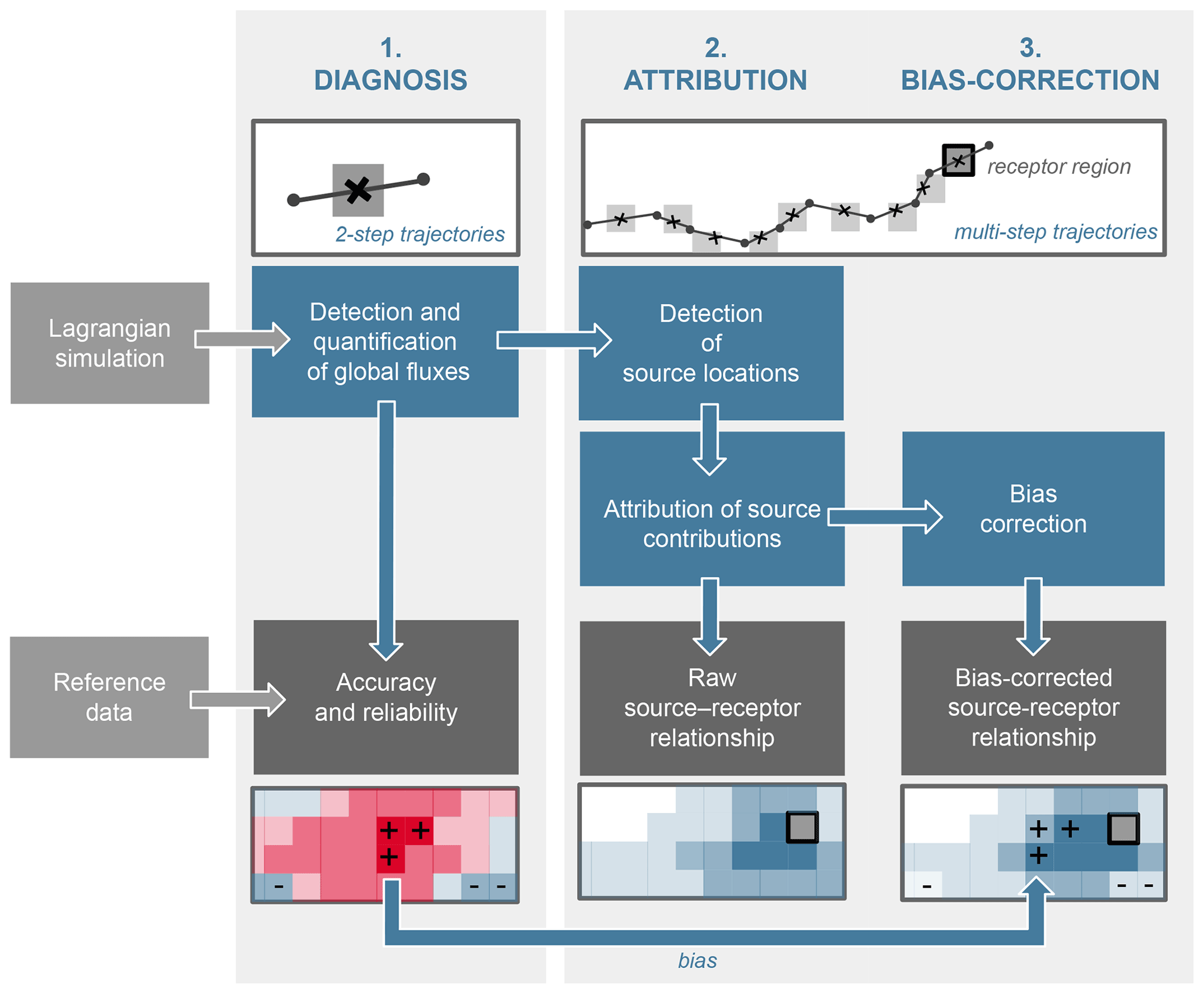 A unified framework to estimate the origins of atmospheric moisture and heat using Lagrangian modelsJ. Keune, D. L. Schumacher, and D. G. MirallesGeoscientific Model Development, 2022
Despite the existing myriad of tools and models to assess atmospheric source–receptor relationships, their uncertainties remain largely unexplored and arguably stem from the scarcity of observations available for validation. Yet, Lagrangian models are increasingly used to determine the origin of precipitation and atmospheric heat by scrutinizing the changes in moisture and temperature along air parcel trajectories. Here, we present a unified framework for the process-based evaluation of atmospheric trajectories to infer source–receptor relationships of both moisture and heat. The framework comprises three steps: (i) diagnosing precipitation, surface evaporation, and sensible heat from the Lagrangian simulations and identifying the accuracy and reliability of flux detection criteria; (ii) establishing source–receptor relationships through the attribution of sources along multi-day backward trajectories; and (iii) performing a bias correction of source–receptor relationships. Applying this framework to simulations from the Lagrangian model FLEXPART, driven with ERA-Interim reanalysis data, allows us to quantify the errors and uncertainties associated with the resulting source–receptor relationships for three cities in different climates (Beijing, Denver, and Windhoek). Our results reveal large uncertainties inherent in the estimation of heat and precipitation origin with Lagrangian models, but they also demonstrate that a source and sink bias correction acts to reduce this uncertainty. The proposed framework paves the way for a cohesive assessment of the dependencies in source–receptor relationships.
- SciAdv
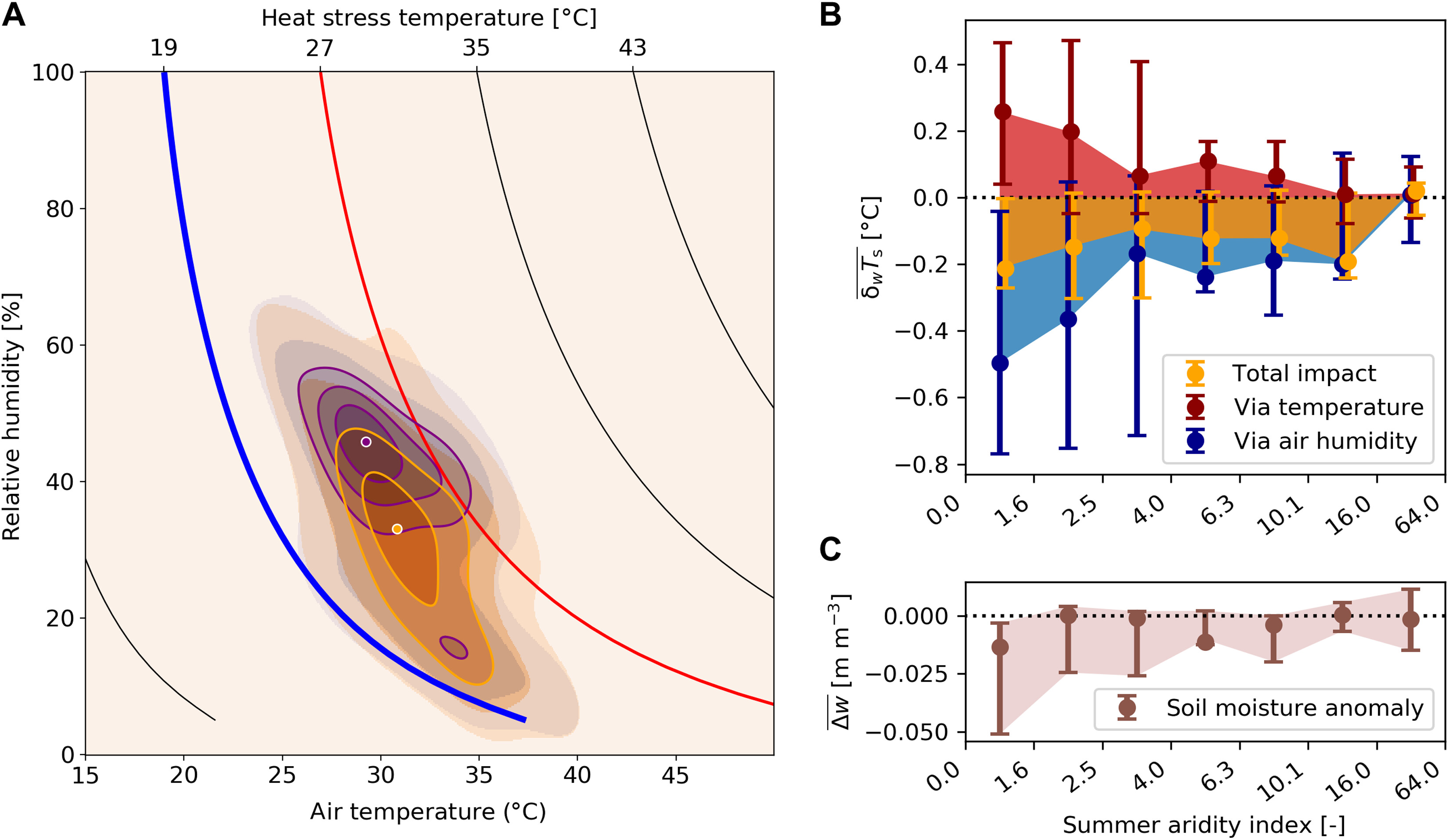 Soil drought can mitigate deadly heat stress thanks to a reduction of air humidityH. Wouters, J. Keune, I. Y. Petrova, and 5 more authorsScience Advances, 2022
Global warming increases the number and severity of deadly heatwaves. Recent heatwaves often coincided with soil droughts that intensify air temperature but lower air humidity. Since lowering air humidity may reduce human heat stress, the net impact of soil desiccation on the morbidity and mortality of heatwaves remains unclear. Combining weather balloon and satellite observations, atmospheric modelling, and meta-analyses of heatwave mortality, we find that soil droughts—despite their warming effect—lead to a mild reduction in heatwave lethality. More specifically, morning dry soils attenuate afternoon heat stress anomaly by 5%. This occurs because of reduced surface evaporation and increased entrainment of dry air aloft. The benefit appears more pronounced during specific events, such as the Chicago 1995 and Northern U.S. 2006 and 2012 heatwaves. Our findings suggest that irrigated agriculture may intensify lethal heat stress, and question recently proposed heatwave mitigation measures involving surface moistening to increase evaporative cooling.
- WRR
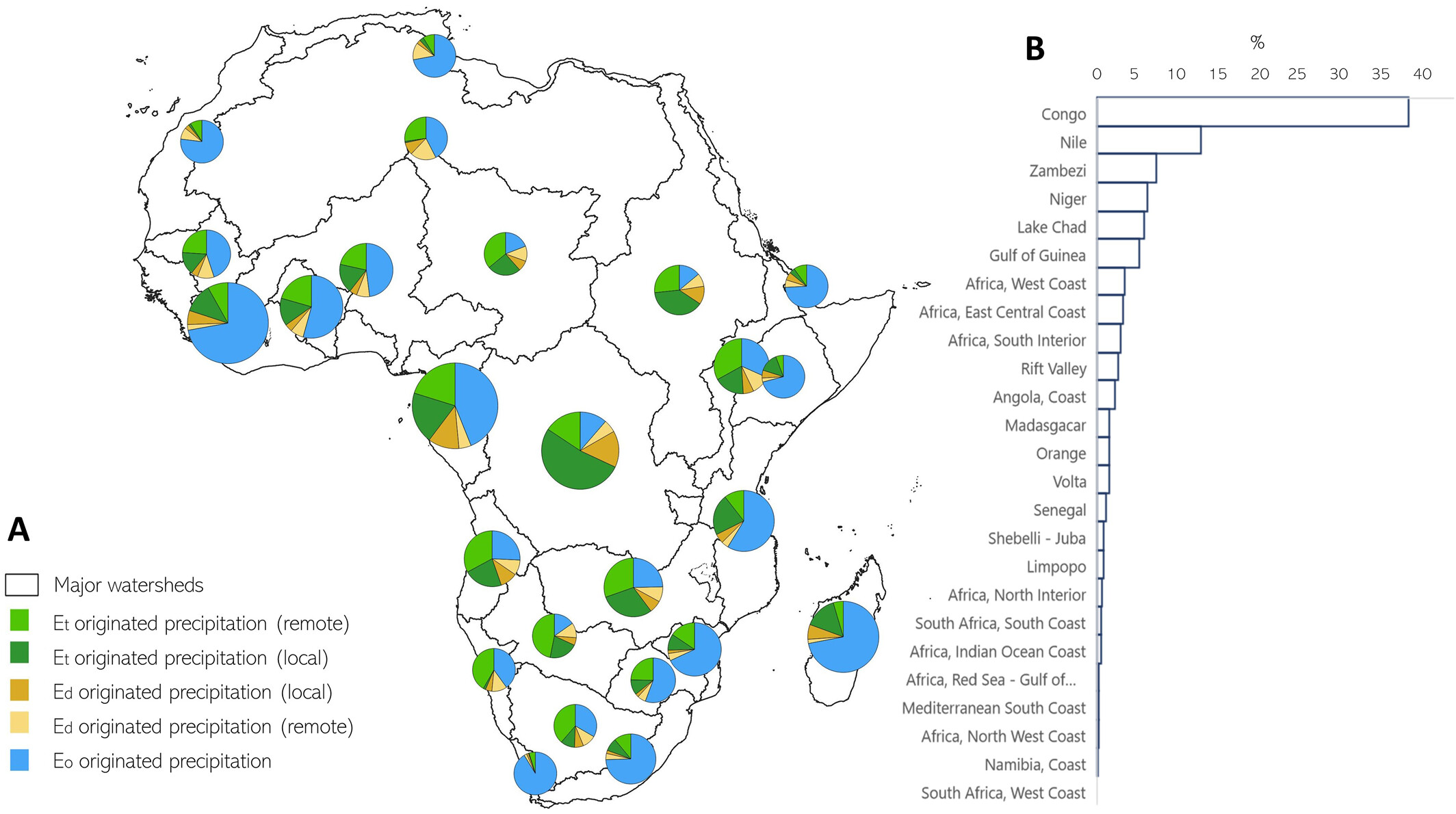 The Contribution of Transpiration to Precipitation Over African WatershedsS. A. Te Wierik, J. Keune, D. G. Miralles, and 5 more authorsWater Resources Research, 2022
The redistribution of biological (transpiration) and non-biological (interception loss, soil evaporation) fluxes of terrestrial evaporation via atmospheric circulation and precipitation is an important Earth system process. In vegetated ecosystems, transpiration dominates terrestrial evaporation and is thought to be crucial for regional moisture recycling and ecosystem functioning. However, the spatial and temporal variability in the dependency of precipitation on transpiration remains understudied, particularly in sparsely sampled regions like Africa. Here, we investigate how biological and non-biological sources of evaporation in Africa contribute to rainfall over the major watersheds in the continent. Our study is based on simulated atmospheric moisture trajectories derived from the Lagrangian model FLEXPART, driven by 1^∘ resolution reanalysis data over 1981–2016. Using daily satellite-based fractions of transpiration over terrestrial evaporation, we isolate the contribution of vegetation to monthly rainfall. Furthermore, we highlight two watersheds (Congo and Senegal) for which we explore intra- and interannual variability of different precipitation sources, and where we find contrasting patterns of vegetation-sourced precipitation within and between years. Overall, our results show that almost 50% of the annual rainfall in Africa originates from transpiration, although the variability between watersheds is large (5%–68%). We conclude that, considering the current and projected patterns of land use change in Africa, a better understanding of the implications for continental-scale water availability is needed.
2020
- ANYAS
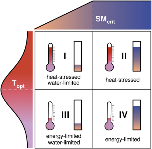 Atmospheric heat and moisture transport to energy-and water-limited ecosystemsD. L. Schumacher, J. Keune, and D. G. MirallesAnnals of the New York Academy of Sciences, 2020
The land biosphere is a crucial component of the Earth system that interacts with the atmosphere in a complex manner through manifold feedback processes. These relationships are bidirectional, as climate affects our terrestrial ecosystems, which, in turn, influence climate. Great progress has been made in understanding the local interactions between the terrestrial biosphere and climate, but influences from remote regions through energy and water influxes to downwind ecosystems remain less explored. Using a Lagrangian trajectory model driven by atmospheric reanal- ysis data, we show how heat and moisture advection affect gross carbon production at interannual scales and in different ecoregions across the globe. For water-limited regions, results show a detrimental effect on ecosystem pro- ductivity during periods of enhanced heat and reduced moisture advection. These periods are typically associated with winds that disproportionately come from continental source regions, as well as positive sensible heat flux and negative latent heat flux anomalies in those upwind locations. Our results underline the vulnerability of ecosystems to the occurrence of upwind climatic extremes and highlight the importance of the latter for the spatiotemporal propagation of ecosystem disturbances.
2019
- WRR
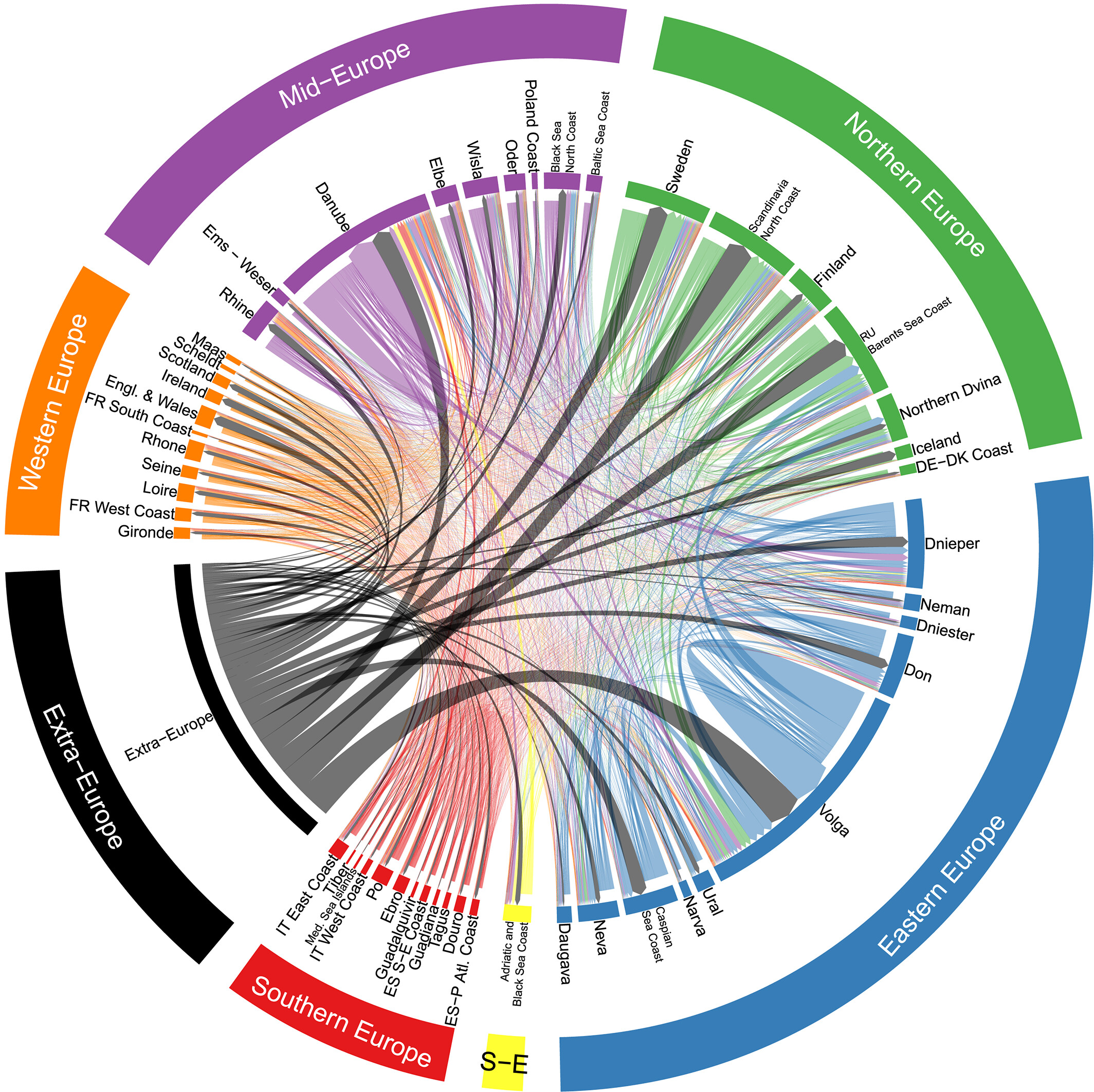 A precipitation recycling network to assess freshwater vulnerability: Challenging the watershed conventionJ. Keune and D. G. MirallesWater Resources Research, 2019
Water resources and water scarcity are usually regarded as local aspects for which a watershed-based management appears adequate. However, precipitation, as a main source of freshwater, may depend on moisture supplied through land evaporation from outside the watershed. This notion of evaporation as a local “green water” supply to precipitation is typically not considered in hydrological water assessments. Here we propose the concept of a watershed precipitation recycling network, which establishes atmospheric pathways and links land surface evaporation as a moisture supply to precipitation, hence contributing to local but also remote freshwater resources. Our results show that up to 74% of summer precipitation over European watersheds depends on moisture supplied from other watersheds, which contradicts the conventional consideration of autarkic watersheds. The proposed network approach illustrates atmospheric pathways and enables the objective assessment of freshwater vulnerability and water scarcity risks under global change. The illustrated watershed interdependence emphasizes the need for global water governance to secure freshwater availability.
- NGeo
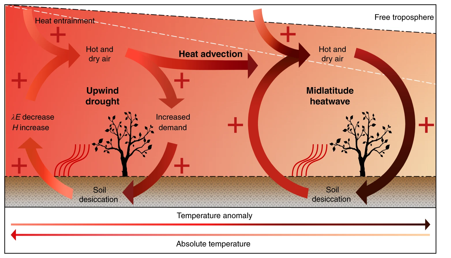 Amplification of mega-heatwaves through heat torrents fuelled by upwind droughtD. L. Schumacher, J. Keune, C. C. Van Heerwaarden, and 3 more authorsNature Geoscience, 2019
Mega-heatwaves are among the deadliest natural disasters in midlatitudes. During such events, the atmospheric circulation is typically governed by persistent anticyclones, enabling cloud-free conditions and advection of hot air. Dry soils in heatwave regions are also known to further contribute to the escalation of air temperatures. However, while local land–atmosphere feedbacks are well studied, the same does not apply to the influence of upwind areas, from where heat is advected. Here we investigate reanalysis data using a Lagrangian heat-tracking model to unravel the role of upwind land–atmosphere feedbacks during the two European mega-heatwaves of this century: the events in 2003 and 2010. Our analysis indicates that advected sensible heat can come in torrents, suddenly and intensely, leading to abrupt increases in air temperatures that further strengthen local land–atmosphere feedbacks via soil desiccation. During both mega-heatwaves, about 30% of the advected sensible heat was caused by the drought upwind. Since subtropical droughts are projected to aggravate during this century, in light of our results, this may be accompanied by consequent intensification of midlatitude mega-heatwaves. We therefore recommend considering not only local, but also upwind land cover and land-use management in the design of adaptation strategies against compound drought–heatwave events.
- AFMIncorporating a root water uptake model based on the hydraulic architecture approach in terrestrial systems simulationsM. Sulis, V. Couvreur, J. Keune, and 8 more authorsAgricultural and Forest Meteorology, 2019
A detailed representation of plant hydraulic traits and stomatal closure in land surface models (LSMs) is a prerequisite for improved predictions of ecosystem drought response. This work presents the integration of a macroscopic root water uptake (RWU) model based on the hydraulic architecture approach in the LSM of the Terrestrial Systems Modeling Platform. The novel RWU approach is based on three parameters derived from first principles that describe the root system equivalent conductance, the compensatory RWU conductance, and the leaf water potential at stomatal closure, which defines the water stress condition for the plants. The developed RWU model intrinsically accounts for changes in the root density as well as for the simulation of the hydraulic lift process. The standard and the new RWU approach are compared by performing point-scale simulations for cropland over a sheltered minirhizotron facility in Selhausen, Germany, and validated against transpiration fluxes estimated from sap flow and soil water content measurements at different depths. Numerical sensitivity experiments are carried out using different soil textures and root distributions in order to evaluate the interplay between soil hydrodynamics and plant characteristics, and the impact of assuming time-constant plant physiological properties. Results show a good agreement between simulated and observed transpiration fluxes for both RWU models, with a more distinct response under water stress conditions and with uncertainty in the soil parameterization prevailing to the differences due to changes in the model formulation. The hydraulic RWU model exhibits also a lower sensitivity to the root distributions when simulating the onset of the water stress period. Finally, an analysis of variability across the soil and root scenarios indicates that differences in soil water content are mainly influenced by the root distribution, while the transpiration flux in both RWU models is additionally determined by the soil characteristics.
- ERL
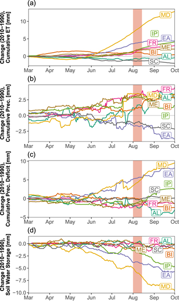 Land use change impacts on European heat and drought: remote land-atmosphere feedbacks mitigated locally by shallow groundwaterS. C. Zipper, J. Keune, and S. KolletEnvironmental Research Letters, 2019
Heat and drought are projected to increase globally but may be mitigated or exacerbated by land use/land cover (LULC) change. Here, we show that remote land-atmosphere feedbacks caused by historical European LULC change led to widespread changes in the energy and water balances, drought, and heat. Using a continental-scale bedrock-to-atmosphere model, we find that LULC change following the Soviet Union collapse and European Union formation may have substantially increased cloud cover and decreased incoming shortwave radiation in western Europe, even in locations where LULC did not change. These changes to the water and energy balances had spatially heterogeneous impacts on drought and heat, including drying in the Mediterranean and Eastern Europe regions. The response of the water and energy balances to remote feedbacks was lessened in areas with shallow groundwater, indicating that local- and continental-scale responses to LULC change are influenced by the coupling between the subsurface, land surface, and atmosphere.
- JGEvidence of daily hydrological loading in GPS time series over EuropeA. Springer, M. A. Karegar, J. Kusche, and 3 more authorsJournal of geodesy, 2019
Loading deformations from atmospheric, oceanic, and hydrological mass changes mask geophysical processes such as land subsidence and tectonic or volcanic deformation. While it is known that hydrological loading plays a role at seasonal time scales, here we demonstrate evidence that also fast water storage changes contribute to daily Global Positioning System (GPS) height time series. So far, no clear strategy, i.e., no single conventional hydrological model, has been proposed for removing hydrological deformation from daily GPS height time series. Hydrological model predictions of total water storage anomalies tend to diverge and (substantially) deviate from Gravity Recovery and Climate Experiment (GRACE) observations, which however have a limited spatial and temporal resolution. Here, we suggest to overcome these limitations by assimilating GRACE data into a high-resolution (12.5 km) hydrological model. We tested this approach over Europe, and we found that accounting for daily hydrological mass changes reduces the root mean square scatter of GPS height time series almost by a factor of two when compared to monthly hydrological mass changes. We suggest that a GRACE-assimilating hydrological model would provide a promising option for removing hydrology-induced vertical deformation from GPS time series also at the global scale.
- HESS
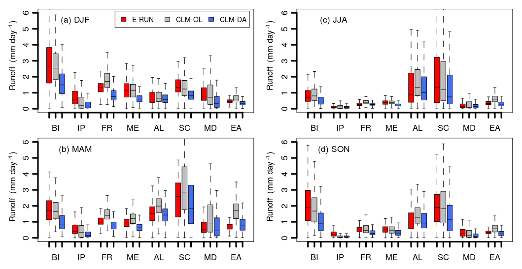 Improving soil moisture and runoff simulations at 3 km over Europe using land surface data assimilationB. S. Naz, W. Kurtz, C. Montzka, and 7 more authorsHydrology and Earth System Sciences, 2019
iAccurate and reliable hydrologic simulations are important for many applications such as water resources management, future water availability projections and predictions of extreme events. However, the accuracy of water balance estimates is limited by the lack of large-scale observations, model simulation uncertainties and biases related to errors in model structure and uncertain inputs (e.g., hydrologic parameters and atmospheric forcings). The availability of long-term and global remotely sensed soil moisture offers the opportunity to improve model estimates through data assimilation with complete spatiotemporal coverage. In this study, we assimilated the European Space Agency (ESA) Climate Change Initiative (CCI) derived soil moisture (SM) information to improve the estimation of continental-scale soil moisture and runoff. The assimilation experiment was conducted over a time period 2000–2006 with the Community Land Model, version 3.5 (CLM3.5), integrated with the Parallel Data Assimilation Framework (PDAF) at a spatial resolution of 0.0275∘ (∼3 km) over Europe. The model was forced with the high-resolution reanalysis COSMO-REA6 from the Hans Ertel Centre for Weather Research (HErZ). The performance of assimilation was assessed against open-loop model simulations and cross-validated with independent ESA CCI-derived soil moisture (CCI-SM) and gridded runoff observations. Our results showed improved estimates of soil moisture, particularly in the summer and autumn seasons when cross-validated with independent CCI-SM observations. The assimilation experiment results also showed overall improvements in runoff, although some regions were degraded, especially in central Europe. The results demonstrated the potential of assimilating satellite soil moisture observations to produce downscaled and improved high-resolution soil moisture and runoff simulations at the continental scale, which is useful for water resources assessment and monitoring.
- JAMES
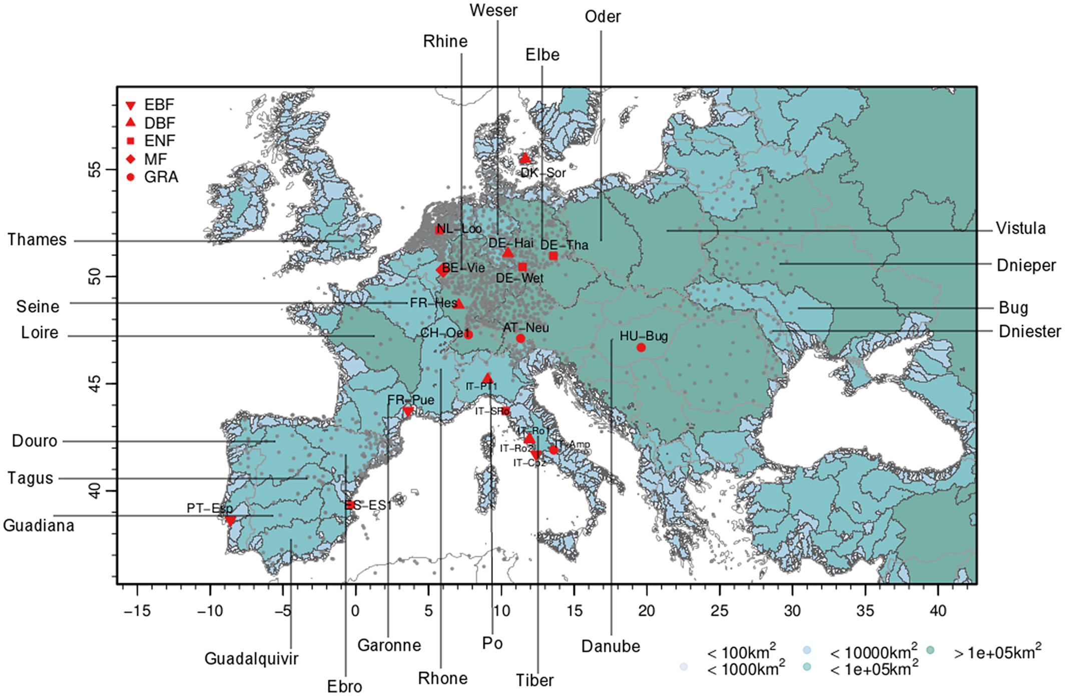 Potential Added Value of Incorporating Human Water Use on the Simulation of Evapotranspiration and Precipitation in a Continental-Scale Bedrock-to-Atmosphere Modeling System: A Validation Study Considering Observational UncertaintyJ. Keune, M. Sulis, and S. J. KolletJournal of Advances in Modeling Earth Systems, Jul 2019
Human activities, such as human water use, have been shown to directly influence terrestrial water fluxes and states. Simulations of soil moisture, river discharge, evapotranspiration, and groundwater storage are significantly improved if human interactions, such as irrigation and groundwater abstraction, are incorporated. Yet improvements through the incorporation of human water use on the simulation of local and remote precipitation are rarely studied but may contribute to the skill of land surface fluxes. In this study, we evaluate the impact of human water use on the skill of evapotranspiration and precipitation in a fully coupled bedrock-to-atmosphere modeling platform. The results show that human water use can potentially increase the skill of the simulations across scales. However, observational uncertainty at the watershed scale limits the identification of model deficiencies and added value related to human water use. Locally, daily precipitation statistics potentially benefit from the incorporation of human water use. Although the incorporation of human water use does not remove the wet bias, it can increase the model skill.
2018
- GRL
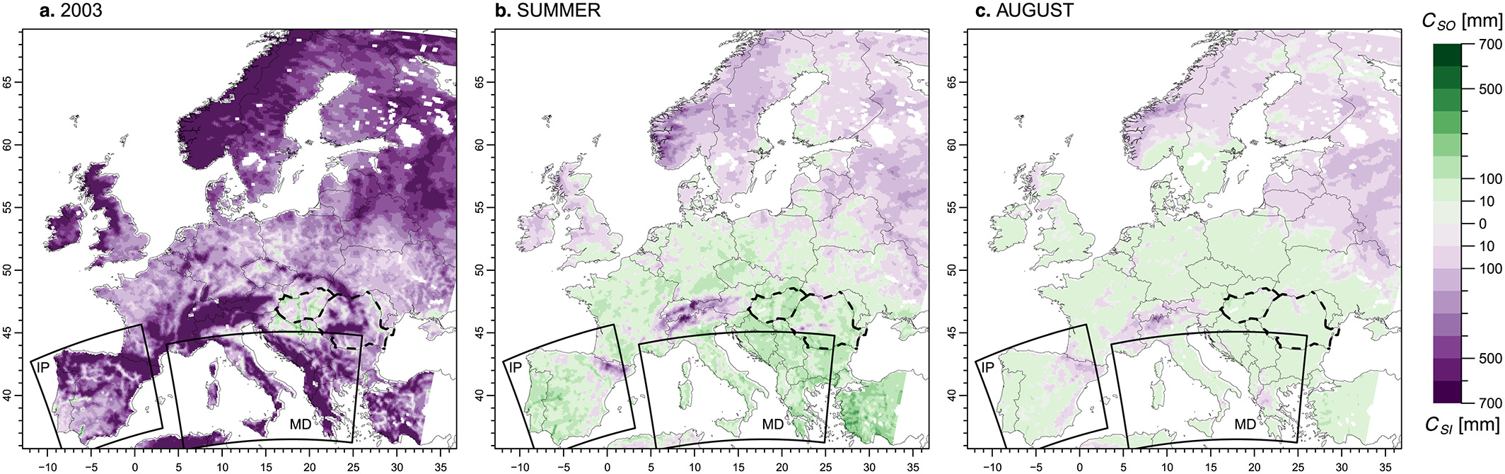 Human water use impacts on the strength of the continental sink for atmospheric waterJ. Keune, M. Sulis, S. Kollet, and 2 more authorsGeophysical Research Letters, 2018
In the hydrologic cycle, continental landmasses constitute a sink for atmospheric moisture as annual terrestrial precipitation commonly exceeds evapotranspiration. Simultaneously, humans intervene in the hydrologic cycle and pump groundwater to sustain, for example, drinking water and food production. Here we use a coupled groundwater-to-atmosphere modeling platform, set up over the European continent, to study the influence of groundwater pumping and irrigation on the net atmospheric moisture import of the continental landmasses, which defines the strength of the continental sink. Water use scenarios are constructed to account for uncertainties of atmospheric feedback during the heatwave year 2003. We find that human water use induces groundwater-to-atmosphere feedback, which potentially weaken the continental sink over arid watersheds in southern Europe. This feedback is linked to groundwater storage, which suggests that atmospheric feedbacks to human water use may contribute to drying of watersheds, thereby raising water resources and socio-economic concerns beyond local sustainability considerations.
- JGR-A
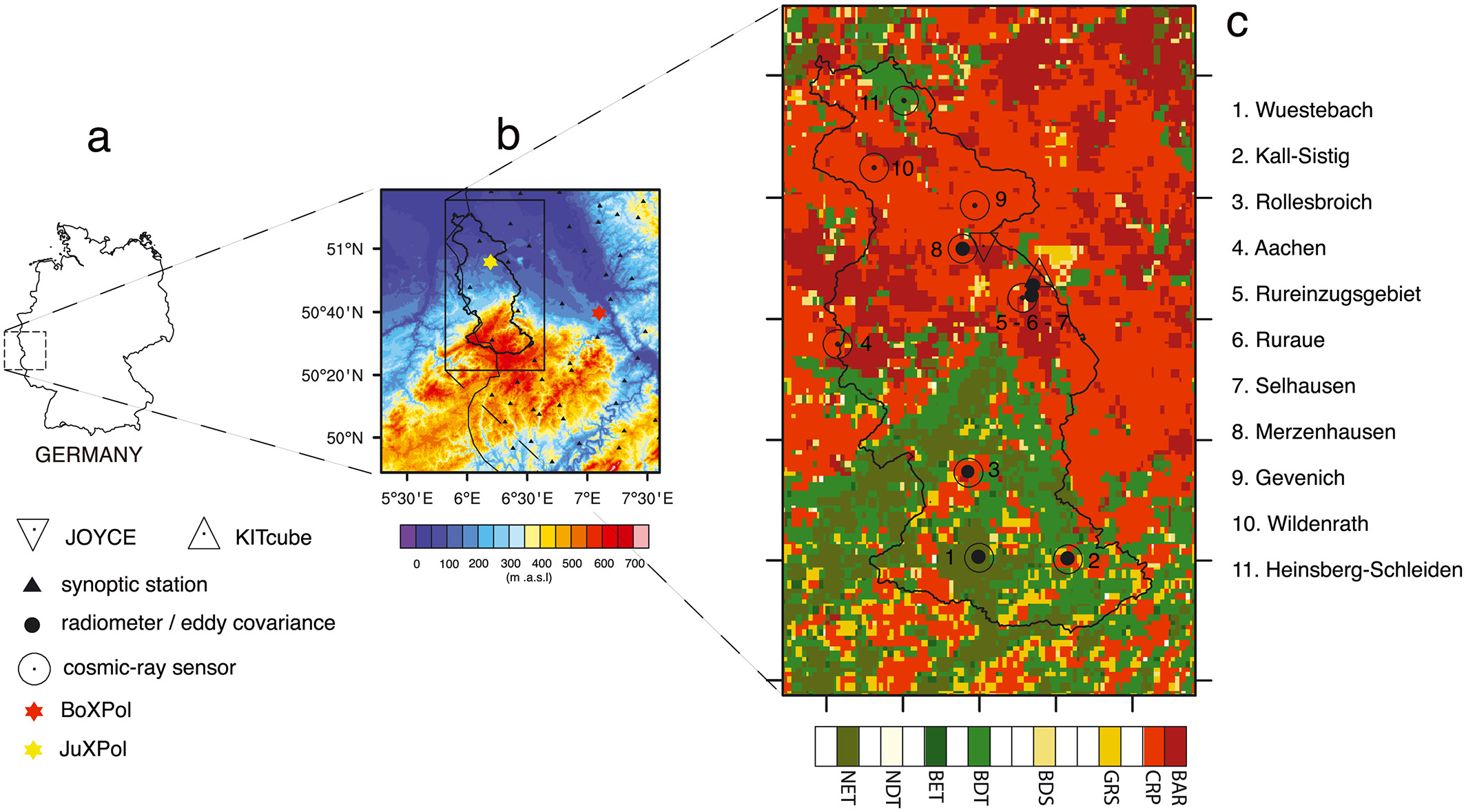 Quantifying the impact of subsurface-land surface physical processes on the predictive skill of subseasonal mesoscale atmospheric simulationsM. Sulis, J. Keune, P. Shrestha, and 2 more authorsJournal of Geophysical Research: Atmospheres, 2018
Integrated terrestrial system modeling platforms, which simulate the 3-D flow of water both in the subsurface and the atmosphere, are expected to improve the realism of predictions through a more detailed physics-based representation of hydrometeorological processes and feedbacks. We test this expectation by evaluating simulation results from different configurations of an atmospheric model with increasing complexity in the representation of land surface and subsurface physical processes. The evaluation is performed using observations during the (HD(CP)2) Observational Prototype Experiment field campaign in April–May 2013 over western Germany. The augmented model physics do not improve the prediction of daily cumulative precipitation and minimum temperature during this period. Moreover, a cold bias is introduced in the simulated daily maximum temperature, which decreases the performance of the atmospheric model with respect to its standard configuration. The decreased performance in the maximum temperature is traced in part to a higher simulated soil moisture, which shifts surface flux partitioning toward higher latent and lower sensible heat fluxes. The better reproduced air temperature profiles simulated by the standard atmospheric model comes, however, with an overestimated heat flux at the land surface caused by a warm bias in the simulated soil temperature. Simulated atmospheric states do not correlate significantly with differences in soil moisture and temperature; thus, different turbulent flux parameterizations dominate the propagation of the subsurface signal into the atmosphere. The strong influence of the lateral synoptic forcings on the results suggests, however, the need for further investigations encompassing different weather situations or regions with stronger land-atmosphere coupling conditions.
- WATER
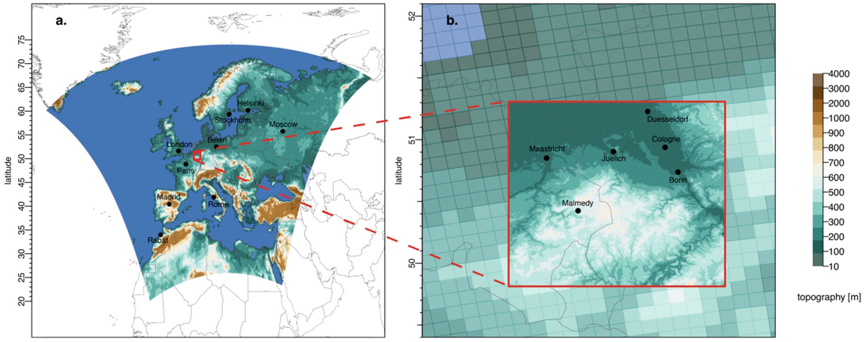 Introduction of an experimental terrestrial forecasting/monitoring system at regional to continental scales based on the terrestrial systems modeling platform (v1. 1.0)S. Kollet, F. Gasper, S. Brdar, and 8 more authorsWater, 2018
Operational weather and flood forecasting has been performed successfully for decades and is of great socioeconomic importance. Up to now, forecast products focus on atmospheric variables, such as precipitation, air temperature and, in hydrology, on river discharge. Considering the full terrestrial system from groundwater across the land surface into the atmosphere, a number of important hydrologic variables are missing especially with regard to the shallow and deeper subsurface (e.g., groundwater), which are gaining considerable attention in the context of global change. In this study, we propose a terrestrial monitoring/forecasting system using the Terrestrial Systems Modeling Platform (TSMP) that predicts all essential states and fluxes of the terrestrial hydrologic and energy cycles from groundwater into the atmosphere. Closure of the terrestrial cycles provides a physically consistent picture of the terrestrial system in TSMP. TSMP has been implemented over a regional domain over North Rhine-Westphalia and a continental domain over Europe in a real-time forecast/monitoring workflow. Applying a real-time forecasting/monitoring workflow over both domains, experimental forecasts are being produced with different lead times since the beginning of 2016. Real-time forecast/monitoring products encompass all compartments of the terrestrial system including additional hydrologic variables, such as plant available soil water, groundwater table depth, and groundwater recharge and storage.
2016
- JGR-A
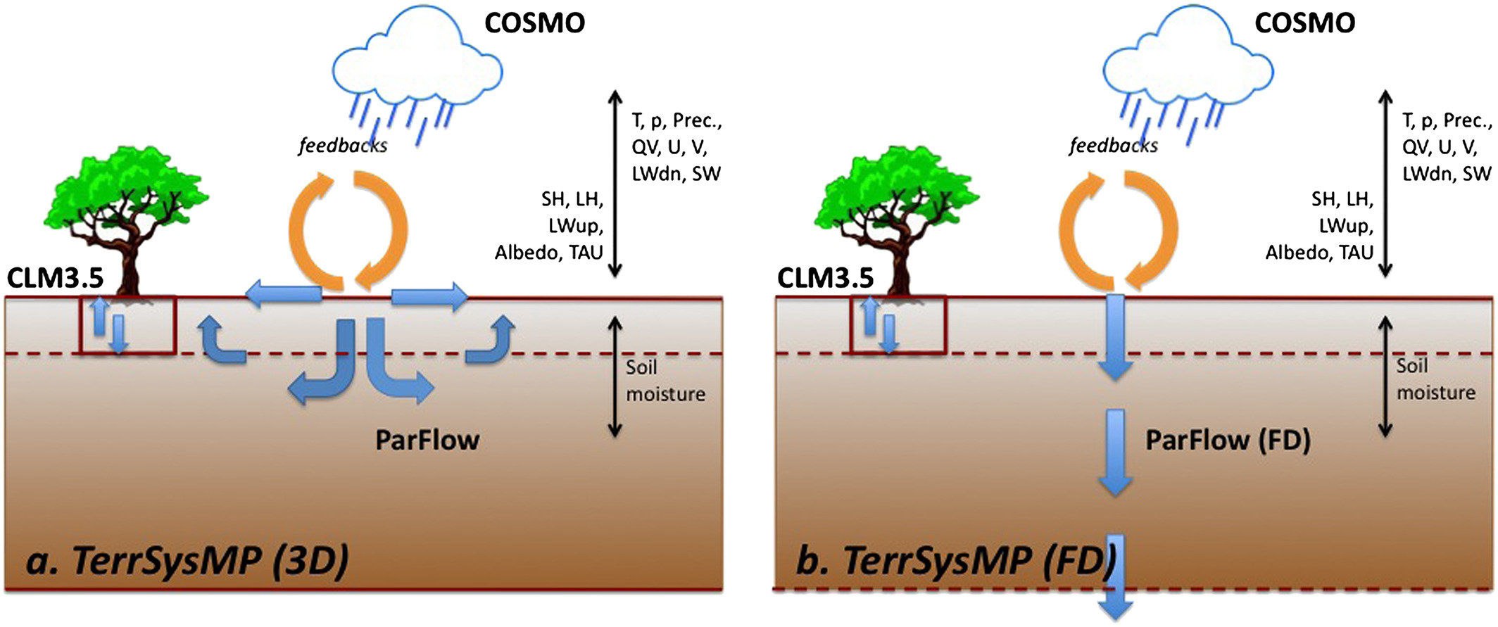 Studying the influence of groundwater representations on land surface-atmosphere feedbacks during the European heat wave in 2003J. Keune, F. Gasper, K. Goergen, and 4 more authorsJournal of Geophysical Research: Atmospheres, 2016
The impact of 3D groundwater dynamics as part of the hydrologic cycle is rarely considered in regional climate simulation experiments. However, there exists a spatial and temporal connection between groundwater and soil moisture near the land surface, which can influence the land surface-atmosphere feedbacks during heat waves. This study assesses the sensitivity of bedrock-to-atmosphere simulations to groundwater representations at the continental scale during the European heat wave 2003 using an integrated fully coupled soil-vegetation-atmosphere model. The analysis is based on the comparison of two groundwater configurations: (1) 3D physics-based variably saturated groundwater dynamics and (2) a 1D free drainage (FD) approach. Furthermore, two different subsurface hydrofacies distributions (HFD) account for the uncertainty of the subsurface hydraulic characteristics, and ensemble simulations address the uncertainty arising from different surface-subsurface initial conditions. The results show that the groundwater representation significantly impacts land surface-atmosphere processes. Differences between the two groundwater configurations follow subsurface patterns, and the largest differences are observed for shallow water table depths. While the physics-based setup is less sensitive to the HFD, the parameterized FD simulations are highly sensitive to the hydraulic characteristics of the subsurface. An analysis of variance shows that both, the groundwater configuration and the HFD, induce variability across all compartments with decreasing impact from the subsurface to the atmosphere, while the initial condition has only a minor impact.
2015
- QJRMSTowards a high-resolution regional reanalysis for the European CORDEX domainC. Bollmeyer, J. D. Keller, C. Ohlwein, and 9 more authorsQuarterly Journal of the Royal Meteorological Society, 2015
Atmospheric reanalyses covering the European region are mainly available as part of relatively coarse global reanalyses. The aim of this article is to present the development and evaluation of a next generation regional reanalysis for the European CORDEX EUR-11 domain with a horizontal grid spacing of approximately 6 km. In this context, a reanalysis is understood to be an assimilation of heterogeneous observations with a physical model such as a numerical weather prediction (NWP) model. The reanalysis system presented here is based on the NWP model COSMO by the German Meteorological Service (Deutscher Wetterdienst) using a continuous nudging scheme. In order to assess the added value of data assimilation, a dynamical downscaling experiment has been conducted, i.e. an identical model set-up but without data assimilation. Both systems have been evaluated for a 1 year test period, employing standard measures such as analysis increments, biases, or log-odds ratios, as well as tests for distributional characteristics. An important aspect is the evaluation from different perspectives and with independent measurements such as satellite infrared brightness temperatures using forward operators, integrated water vapour from GPS stations, and ceilometer cloud cover. It can be shown that the reanalysis better resolves local extreme events; this is basically an effect of the higher spatio-temporal resolution, as known from dynamical downscaling approaches. However, an important criterion for regional reanalyses is the coherence with independent observations of high temporal and spatial resolution, resulting in significant improvement over dynamical downscaling. The system is intended to become operational within a year, continuously reprocessing and evaluating longer time periods. The reanalysis data are planned to become available to the research community within a year.
2014
- MWR
 Multivariate probabilistic analysis and predictability of medium-range ensemble weather forecastsJ. Keune, C. Ohlwein, and A. HenseMonthly Weather Review, 2014
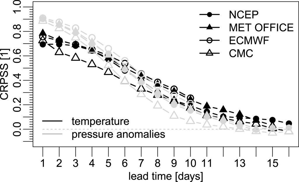
Ensemble weather forecasting has been operational for two decades now. However, the related uncertainty analysis in terms of probabilistic postprocessing still focuses on single variables, grid points, or stations. Inevitable dependencies in space and time and between variables are often ignored. To address this problem, two probabilistic postprocessing methods are presented, which are multivariate versions of Gaussian fit and kernel dressing, respectively. The multivariate case requires the estimation of a full rank, invertible covariance matrix. For this purpose, a Graphical Least Absolute Shrinkage and Selection Operators (GLASSO) estimator has been employed that is based on sparse undirected graphical models regularized by an L1 penalty term in order to parameterize the full rank inverse covariance. In all cases, the result is a multidimensional probability density. The forecasts used to test the approach are station forecasts of 2-m temperature and surface pressure from four main global ensemble prediction systems (EPS) with medium-range weather forecasts: the NCEP Global Ensemble Forecast System (GEFS), the Met Office Global and Regional Ensemble Prediction System (MOGREPS), the Canadian Meteorological Centre (CMC) Global Ensemble Prediction System (GEPS), and the ECMWF EPS. To evaluate the multivariate probabilistic postprocessing, especially the uncertainty estimates, common verification methods such as the analysis rank histogram and the continuous ranked probability score (CRPS) are applied. Furthermore, a multivariate extension of the CRPS, the energy score, allows for the verification of a complete medium-range forecast as well as for determining its predictability. It is shown that the predictability is similar for all of the examined ensemble prediction systems, whereas the GLASSO proved to be a useful tool for calibrating the commonly observed underdispersion of ensemble forecasts during the first few lead days by using information from the full covariance matrix.